3miles round Trip (more when including TurtleBack Falls)
Strenuous
1.5hrs hiking time round trip
No surprise we went out to check out a hike this weekend with my brother in law in town. After a suggestion from a friend, Butch, and reminder from my husband that this would be a great hike, we ventured that way. What I knew, was it was on the other side of Brevard. It’s in Sapphire, so a bit past Brevard in relation to Asheville. Essentially travel takes a little over an hour from Asheville. After passing through Brevard, you travel through beautiful Lake Toxaway and into Sapphire. I had never traveled these roads, however they are fairly curvy. There is a convienient store/gas station near Gorges State Park, however they were out of gas while we were there… perhaps a result of the current gas situation due to the last hurricane…
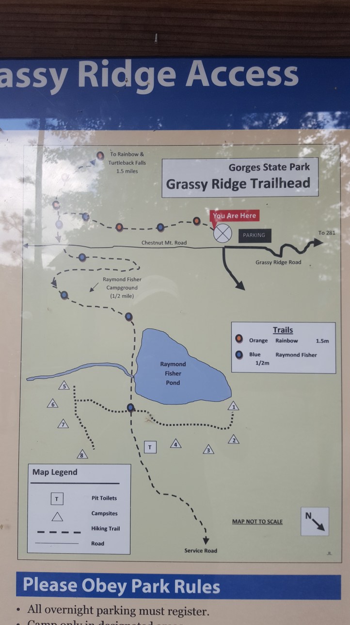
We followed 64 all the way until you turn left onto 281. About a mile down the road is Gorges state park. My mom asked me if it was ‘gorgeous’ and it truly is a great looking state park. Stop by the visitor’s center on your way in and get a map, take a bathroom break, and look at the gift shop. It’s a nice setup.

After pulling out of the visitor’s center, we took a right an followed the road to the right. We followed signs to the Grass Ridge Parking area. The parking lot was pretty full when we arrived. There was even a snow cone kiosk set up outside the parking lot… I’d never seen anything like that before at a park like this… It was around 3pm when we arrived.


At the end of the parking lot, there’s an obvious trail start. Info on the trail states that its a primarily downhill walk to the falls. 1.5 miles one way. (If you take the trail from the 281 entrance outside of the park, this hike is 1 mile exactly to the falls)


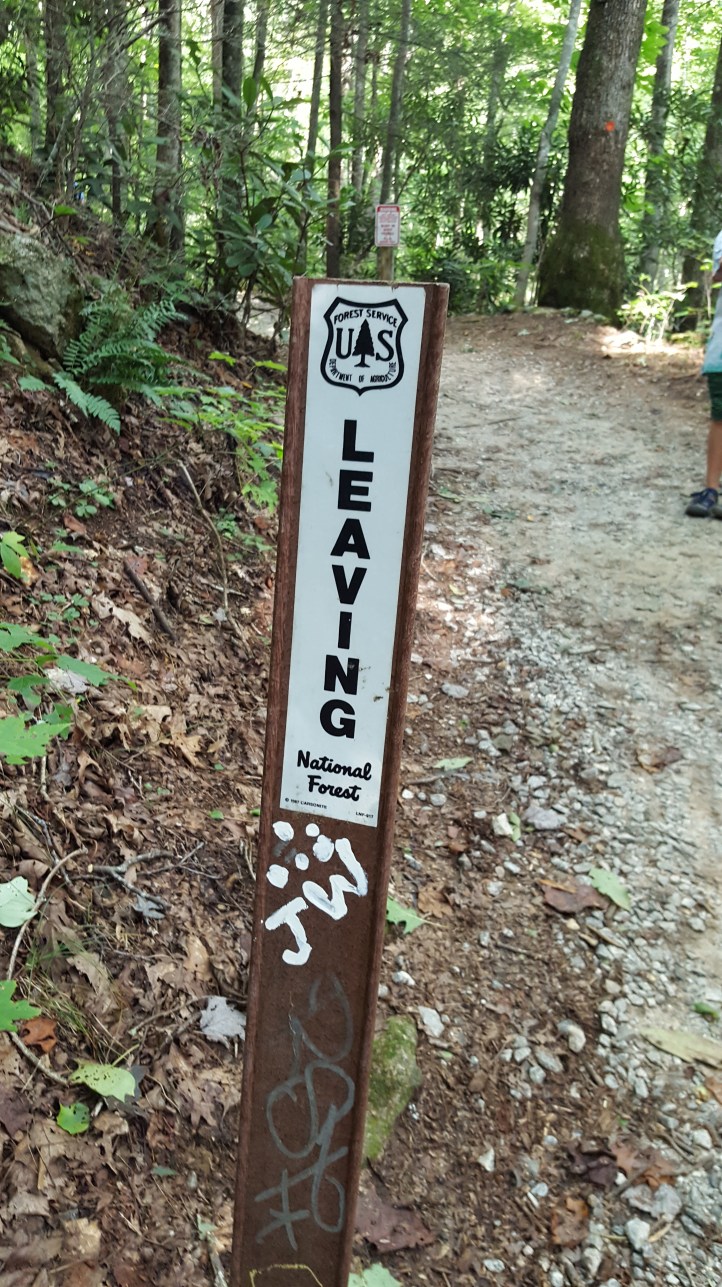
We start the trail and follow. It is marked with orange blaze marks. At around .25 miles you’ll see the sign pointing you to take a right to continue to Rainbow Falls. You’ll see a sign around .5-.75 miles that indicates you are leaving the Gorges State Park and Entering the Pisgah National Forest. You’ll be able to tell that it is not as well cared for after passing this point. You also no longer have blaze marks to follow, which is disappointing. However luckily the trail is pretty well traveled and easy to follow.


The trail is decently wide. Well traveled. Considered Strenuous.


I didn’t use my mapquest on this trail, however at approximately 1 mile we start seeing off-shoot entrances into the water. We poke in and out of the water entrances and look at the water. There are some small falls along the way that were really pretty to look at. Being it was our first time, we weren’t sure if these were Rainbow Falls… however don’t be confused… they are very obvious when you arrive.


Continue through the trail, including stairs, to reach the falls. When you reach it you will have a wooden walkway for a viewing area.
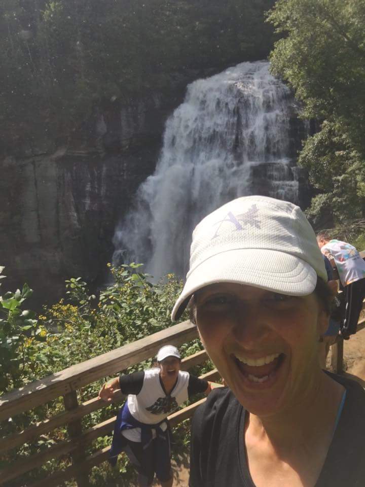
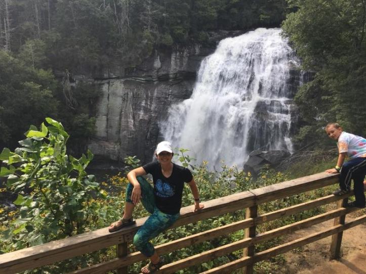
After crossing the bridge, you’ll see the trail splits. If you go left, you will follow a trail that takes you closer to the falls. The first break off down hill takes you to an older viewing area. A tree has fallen here and the viewing area isn’t repaired, however the view here is very close. Continuing on this trail will take you to a rocky area that is right to the side of the falls. We chose to not play here, although I’m sure some do. It didn’t look safe enough to play.

Beware, there were yellow-jackets everywhere near the falls and trails. If you are allergic, take Benadryl, Epi-Pens, etc. We ran into a guy who’s face was puffed up from a sting, and another woman who had multiple stings but no reaction. I had nothing to offer and we were 45 min from a station with minimal cell service.
From that nice wooden fence at Rainbow falls, the split that took you to the right takes you around and up to the top of the falls by stairs (Another big tree has fallen over the stairs that we have to climb around)


After reaching the top, you will feel like you are walking by a rock wall. Take an immediate left, almost going backwards a little. There’s a small trail that will take you to the rock that sits at the very top of the falls. From here you can look over the falls. Be careful, this is safe if the weather is dry, but I wouldn’t test it with ice or water, as the falls are 125ft tall. You can follow the rocks to the right to move further up the river and eventually rejoin the trail.


Once back on the trail, continue on for less than .25 of a mile and you’ll see TurtleBack Falls. You can actually see this from the same rock that looks over Rainbow Falls.
At TurtleBack Falls, you can climb up using a rope from the left, or trail entrance from the right… creep to the top of the water and slide in, and you can slide down the falls. What an experience! We watched others do this. A reading up on this told me that there have been people die on these falls if they aren’t strong swimmers or the water was up due to lots of rain. So slide at your own risk! Definitely have others with you to help if needed. And if you plan to do this- don’t forget your towel and dry clothes! It’s a long hike back out to try wet…


The trail continues on another .77miles to where the trail entrance from 281 is, however this is where we turned around.
It took us approximately 45 min to walk in (mostly downhill with a few stops to view) and then 50 min to walk out (mostly uphill)
There appear to be multiple other falls and hikes in Gorges State Park, however these are all we worked with. If you wanted to make a day of it, there are picnic tables and places that make it easy to pack a lunch and find new locations to explore, or camp!
